Know Your Drone
The revolution in small, unmanned aircraft calls for caution

Take a look at the soaring sales of remotely piloted mini aircraft, and plainly there’s a revolution afoot. A highly manoeuvrable device that can weigh several kilogrammes does need to be flown with care, however, in order to protect public safety. After all, ‘unmanned’ doesn’t mean ‘unpiloted’. This becomes all the more evident when we consider that a drone’s size bears no relation to its capabilities: a tiny drone can feasibly be three times more complex than a large one (see below). So, the notion that we can order a drone online today and be flying it tomorrow is misplaced: we need to know what we are doing, because when things go wrong, they go wrong very quickly.
Basic toy drones, available on the high-street, often only suitable for indoor use. Sometimes controlled by a mobile phone or tablet over WiFi. Often able to do tricks like flips. Sometimes themed by various entertainment franchises. Some have low-res cameras on-board.
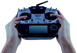
FPV Racing drones with fixed forward-facing First-Person-View cameras transmitting live footage to the pilot and sometimes audiences. Sold in kit form or assembled by the pilots using parts from various suppliers. Extreme power-to-weight ratios mean rapid acceleration to 70mph and above. Some pilots opt for other configurations such as bicopters and tricopters.
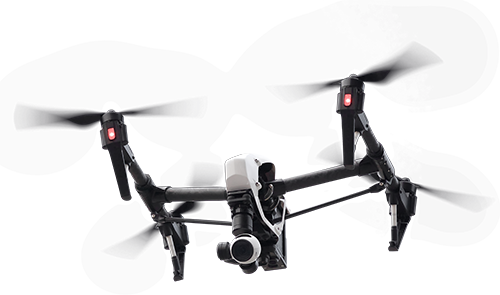
Standard consumer drones (most commonly quadcopters) such as the very popular DJI Phantom range. GPS capabilities allow for semi-autonomous features such as RTH (Return To Home). Usually carry high-res cameras, often mounted on electronically-stabilised gimbals.
Hardware generally the same as Standard Drones. More advanced software features such as way-point navigation and "follow" modes. Ability to have camera controlled by a separate controller.
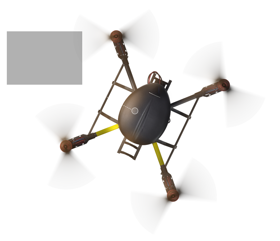
Very high quality cameras (4K, Thermal imaging) or specialised sensors such as agricultural inspection, often combined with other sensors to build 3D maps of buildings or detect architectural issues (e.g. damaged roof-tiles). Retractable undercarriage/legs. These multicopters are likely to have more redundancy (safety for the drone itself, its payload, and people and property) by having 6 or more motors in various configurations (hexacopters, octocopters, X4). More power to lift greater loads for longer times.
 ›
›


Drones have shot up the popularity chart as the boy’s toy, and they are well on their way to becoming the new must-have recreational items du jour. Look at the take-up rate among the social media-savvy generation, for one thing: Why stop at selfie sticks when you can mount a camera on a drone and get pin-sharp aerial footage of an entire event, such as your wedding? And who wants to be left out of racing their friends round an obstacle course, when all it takes is a pair of navigational goggles linked to a camera at the front of their drone? Especially when the fun factor is helped along by entry prices as low as £30 (although they do go all the way up to £30,000), as illustrated in the diagram above.
It’s estimated that British consumers purchased 530,000 drones in 2014 – certainly, electronics retailer Maplin reckoned that store sales were up 300% on the previous year, and that was before the Christmas rush. In 2015, global sales were predicted to treble in the next two years, taking the figure to 1.2 million. We could be looking at mankind’s new Drone Era.
Flying a drone with a camera over private property can be interpreted as surveillance, which would be in clear breach of Article 8.
Aside from entertainment, Civil Aviation Authority (CAA) figures show that as of December 2015, 1302 commercial operators were given permission to conduct aerial work – compared with £1,500 an hour for helicopter and crew hire, drones are rightly regarded as cheap as chips. “Drones are already being widely used commercially in the UK,” says CAA Policy Director Tim Johnson. “Their primary purpose is for aerial filming or photography, surveying and inspection work, and search and rescue, with more opportunities likely in the future. However, it’s vital that the drone industry doesn’t create hazards for other aviation users. All commercial drone operations require permission to fly from the CAA. This approach is safety driven but proportionate in its approach, and we’re keen that as it evolves the regulatory framework is both effective and proportionate to the safety risk.”
The aviation regulations are covered in CAP 393, Air Navigation: The Order and the Regulations (ANO 2009), articles 166 and 167, which address the key aspects of personal responsibility, distance and altitude, and article 138, which covers the need to respect the safety of persons or property when flying a drone. If you’re new to droning, download a copy of the CAA’s flyer, CAP 1202, for a reminder of the basic operational regulations. “Anyone using a drone should apply common sense when thinking about where to fly,” adds CAA’s Tim Johnson. “It’s clearly irresponsible to fly any device near an airport or flight paths, for example. You need to consider all aspects of your surroundings before every flight and keep a safe distance from people, buildings and vehicles and you must not fly it out of your sight. The CAA has developed a Dronecode offering straightforward guidance on how to fly safely, which we urge drone users to adopt, because anyone breaching those rules can be prosecuted.”
James Harvey, NATS Safety Engineer, is a case in point: “If you want to fly your drone commercially, as I do for photographic assignments, you need a PFAW (Permission For Aerial Work) from the CAA. To obtain this, the CAA first wants to see that you are competent in flying, that your operational procedures are safe, and that you’re insured – and insurance is directly linked to compliance with the CAA’s requirements. You’ll need proof, which means getting a qualification such as NATS’ RPAS course.”
Although commercial drone pilots require permission from the CAA, recreational users with drones carrying cameras should not fly their drones within 150 metres of a congested area or large crowds, and must not fly within 50 metres of a person, vessel, vehicle or structure that isn’t under the control of the pilot. Drones with a weight of 20kg or less must be kept within the sight of the person operating it at all times whilst airborne so that potential collisions can be avoided. This ‘visual line of sight’ requirement typically translates as no more than 400ft above the ground or water or 500 metres horizontally. In actual fact, if your drone is 7kg or less, the limit is simply “within direct unaided visual contact sufficient to avoid collision”. However, given their size, 400ft and 500m are most likely the maximum distances at which you can achieve this. If you want to fly drones beyond these limits, you will need explicit permission from the CAA.
There are aspects not covered by current regulations, though – privacy is one potential flashpoint for conflict. Take filming people without their permission, for instance: this is a no-go area covered by Article 8 of the European Convention on Human Rights Act, by which everyone has the right to respect for private life, family life and home. It’s the latter that can easily lead to falling foul of privacy laws: Flying a drone with camera over private property can be interpreted as surveillance, which would be in clear breach of Article 8. If the general public is concerned about invasion of privacy, just imagine the explosion of lawsuits that apparent drone snooping would provoke if celebrities were the targets.

“It is vital that the drone industry doesn’t create hazards for other aviation users. All commercial drone operations require permission to fly from the CAA. This approach is safety driven and we are keen that as it evolves the regulatory framework is both effective and proportionate to the safety risk.”
The impact of a drone sighting is very similar to an infringement, with one major difference: unlike an infringement, it’s not possible for air traffic controllers to vector aircraft around or away from small drones, because they can’t be spotted in time. Radar reflection needs to be approximately one metre square to be spotted, and small drones don’t carry the necessary equipment to be detected by typical primary and secondary radars used by air traffic controllers for seeing and controlling manned aircraft. This means the only way controllers can be aware of a drone in their airspace is if the drone operator tells them, or a pilot has a clear view of it from the aircraft and reports it. When a pilot reports sighting a small drone, the controller will record its approximate location and height and pass this information to any other pilots in the area. They carry on doing this for up to 30 minutes, which is the assumed maximum lifespan of most drone batteries. Pilots can then choose to divert to an alternative airfield or enter a holding pattern to allow time for the drone to clear the airspace. The local Police in the area that the drone was reported must also be informed quickly, so that the chances of identifying (and catching) the person flying the drone can be maximised.
Of the 78 drone incidents reported in the nine and a half years between March 2006 – October 2015, 33 happened in the last three months. Incident numbers are set to rise even more steeply, too, as drones become technologically more sophisticated, sales spiral upwards, and battery life improves, allowing them to stay airborne for longer. Plainly, whether for private or commercial use, safety is crucial: ‘unmanned’ doesn’t mean ‘unpiloted’, and when things go wrong they tend to go wrong very quickly indeed. This was dramatically illustrated by a near miss in March 2015, when a drone came within 50ft of an Airbus A320 as it descended through 1,700ft to land at Heathrow. Other incidents include a Euro 2016 qualifier match in Belgrade that was stopped when a drone appeared over the stadium trailing an Albanian flag, sparking a brawl. More seriously, in August 2013 a man was convicted for dangerous use of a recreational drone after flying within 50m of the Jubilee Bridge in Barrow-in-Furness and then losing control of it over the BAE System submarine-testing facility. That lapse led to a fine of £800 and £3,500 in court costs.
Unquestionably, action needs to be taken before a disaster occurs. To that end, a Drones Public Dialogue sponsored by the Department for Transport, the Ministry of Defence, and Sciencewise took place between December 2015 and February 2016. It was aimed at eliciting the public’s opinions and attitudes and so inform the government strategy which will be published later in 2016. “The government is looking at beyond-line-of-sight operations that will open up new market opportunities,” says Phil Binks, NATS Solution Architect. “A cross-government steering group has drawn up a strategy for drones focusing on three industries: logistics, energies and utilities, and agriculture. They’re aiming to have initial beyond-line-of-sight operations taking place within 18 months, and before the end of this parliamentary term for routine beyond-line-of-sight operations.”
Recorded incidents March 2006 – Sept 2015
To say that drone fever has gripped the business community may be a slight exaggeration, but it’s certainly heading in that direction. A while ago, Binks touched base with a well-known web based retailer at a conference and learned that they are conducting their own R&D programme in the UK, part of which entails trialling delivery drones in Cambridgeshire: “More recently the CEO of Amazon threw down a challenge to government and aviation authorities,” says Binks. “He suggested that if hobbyists were to operate between ground and 200ft, commercial delivery between 200ft and 400ft, and manned aviation above 500ft, this would provide a 100ft safety buffer between manned and unmanned aviation. In theory, this is great, but we must take into account emergency helicopters and military aircraft, which need to be able to safely operate at low level.” Another organisation taking a keen interest is Facebook, which has acquired Ascenta, a Somerset-based drone maker. Says Binks: “Drone usage could be adopted by some essential services, too: Blood Transfusion Services spend huge sums of money transporting blood products either by air or road from blood banks to hospitals. What if we could use drones to fly blood products across cities and do away with potentially dangerous high-speed car journeys through our busy and congested cities?”
Sharing knowledge is rewarding to all concerned, and to that end, Phil Binks is in touch with NASA in the US, which has set up a UTM (UAS Traffic Management) programme; it is researching prototype technologies for a UTM system that could develop airspace integration requirements for enabling safe, efficient, low-altitude operations. “We want to support NASA because air traffic management is crucial regardless of where we are in the world. In addition, it’s in the interests of manufacturers to ensure standardisation – a one-size-fits-all approach, where the same kit works across international boundaries because it’s more cost effective for them, as well as more convenient for users.”
Binks again: “This is going to be a game-changer. We want to move this industry forward in a collaborative manner, so our view is: ‘Let’s work together in the interests of safe integration.’ NATS want to help get us to the point where drone operators interact safely with other airspace users. Manned and unmanned aviation needs to be able to work together. NATS is solidly behind promoting safety.”

“We want to move this industry forward in a collaborative manner, so our view is: ‘Let’s work together in the interests of safe integration.’ Manned and unmanned aviation needs to be able to work together.”
 Head Office